Bird Observation Map
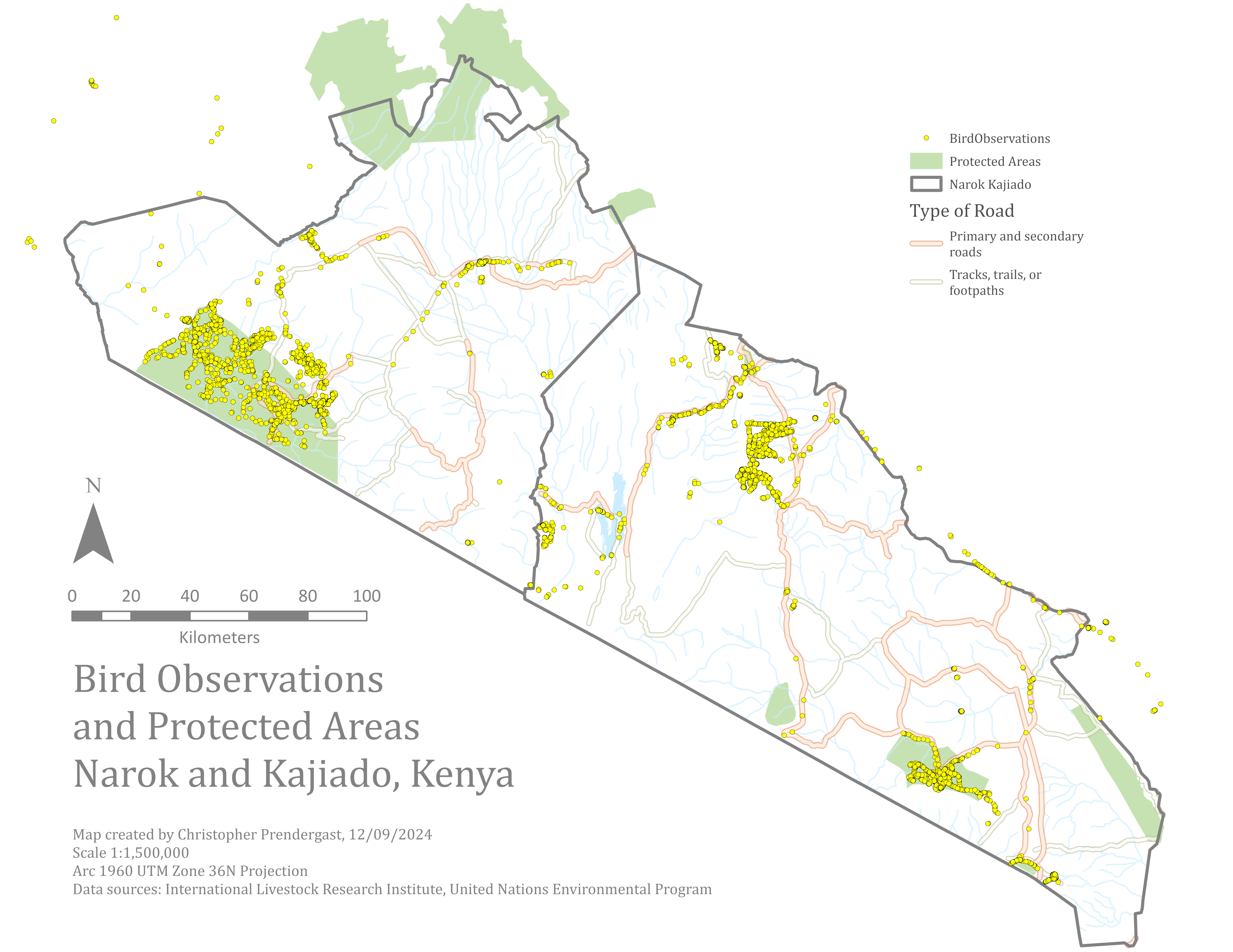
The Bird Observation Map visualizes the spatial distribution of recorded bird sightings within the Narok and Kajiado Districts of Kenya. It combines point-based observation data with geographic context layers to identify patterns in bird presence, habitat use, and potential environmental influences on distribution.
At the core of the map is the Bird Observations point layer, where each location represents a recorded sighting. Attributes linked to each point include species name, observation date, and additional notes. The map emphasizes spatial location rather than species-specific details. The point symbols allow quick visual identification of areas with higher observation density, indicating potential hotspots of avian activity.
Supporting layers, such as Protected Areas and Roads, provide environmental and human-impact context. Protected areas indicate whether observations are concentrated within conservation zones or extend into unprotected lands. Roads serve as orientation features and may also reflect accessibility for birdwatchers, influencing observation patterns.
By combining observation data with spatial context, the Bird Observation Map serves as both a research and management tool. It helps identify priority areas for monitoring, conservation action, or habitat restoration, and provides a baseline visual record for tracking changes in bird distribution over time.
Data Layers and Sources
The Bird Observation Map integrates both primary field data and reference GIS datasets to provide spatial and environmental context.
Data Layers and Sources
| Data Layer | Source | Purpose in Map |
|---|---|---|
| Bird Observations | Field survey data (GPS-recorded sightings, local wildlife monitoring projects) | Core dataset showing the location of each recorded bird sighting. |
| Protected Areas | Kenya Wildlife Service, UNEP-WCMC’s World Database on Protected Areas (WDPA) | Indicates whether observations occur inside or outside conservation zones. |
| Roads | World Food Programme roads dataset (Roads_WFP) | Provides reference features and accessibility context for observation points. |
| Study Area Boundary | Narok_Kajiado administrative boundary layer from project data | Defines the extent of analysis and ensures observations are mapped within the target region. |
Workflow
The workflow to create the Bird Observation Map involved the following steps:
- Added the Narok_Kajiado boundary layer to define the study area.
- Imported the Bird Observations dataset, ensuring coordinates matched the project’s spatial reference.
- Added contextual layers (Roads_WFP and Protected Areas) for environmental and human-impact context.
- Symbolized bird observation points for clarity, while styling supporting layers with contrasting colors and patterns.
- Adjusted the map extent to display all observations within the study area.
- Finalized the layout in ArcGIS Pro by adding a title, legend, scale bar, north arrow, and source information.
- Exported the map in shareable formats for reporting and analysis.
The creation process employed standard geoprocessing and cartographic tools in ArcGIS Pro to prepare, display, and enhance the spatial data.
Tools Used in Creating the Map
| Tool Name | Function | Purpose in Map Creation |
|---|---|---|
| Add Data | Imports spatial and tabular datasets into ArcGIS Pro. | Loads bird observations, study area boundary, and contextual layers. |
| Project | Converts datasets to a common coordinate system. | Ensures all layers align spatially within the map. |
| Symbology | Customizes feature appearance (color, size, style). | Highlights bird observation points and differentiates supporting layers. |
| Labeling | Adds text labels to map features. | Identifies towns, protected areas, and reference features. |
| Select Layer By Location | Selects features based on spatial relationships. | Confirms that bird observations fall within the Narok_Kajiado study area boundary. |
| Spatial Join | Transfers attributes from one layer to another based on spatial location. | Associates each bird sighting with its corresponding land use type and protection status. |
| Layout View | Assembles and finalizes the cartographic composition. | Adds map title, legend, scale bar, north arrow, and source information before export. |