GIS Meetup & Educational Seminar Summary #4
Presented on: Dec 17th, 2018
Presenters:
- Terry Bills - Global Transportation Industry Director at ESRI
- Alberto Nieto (anieto@esri.com) – Solution engineer.
Overview
This talk covers the application of machine intelligence in ArcGIS to the transportation sector. Transport Departments can gain critical insights from the analysis of digital data. Artificial intelligence includes machine intelligence and deep learning where deep learning is a subset of machine intelligence. The focus of this talk is machine intelligence which enables data driven algorithms that can automate the analysis tasks of classification, clustering, and prediction. Whereas traditional machine learning uses geographic data as the key to join disparate datasets, spatial machine learning goes one step further and incorporates geographic information in the computations. Typical geographic computations include shape, density, contiguity, spatial distributions, and proximity. ArcGIS offers deep learning through integration with frameworks such as PyTorch, Keras, CNTK, TensorFlow, fast.ai, and scikit-learn. Machine learning is computationally intensive and has been enabled by recent developments in parallel and distributed processing. The first step in any machine learning project is to ask, “what question are you trying to answer?”
Practical Applications
Practical applications of machine intelligence in the transportation sector include safety analysis looking for patterns in crash data, pedestrian and vehicle identification using feature extraction, pavement condition analysis, traffic management systems, and autonomous vehicles. Several applications of this technology were demonstrated including the following: -
-
Classification involves deciding categories for observations using training data. One type of classification problem is to detect objects by extracting feature data from video images. This approach was demonstrated using the example of the SunTrust baseball park which employed IBM Watson and ArcGIS to identify pedestrian traffic and feed that information to a dashboard and automatically adjust traffic signals. A second example was demonstrated using data from Jackson Hole, WY, where live traffic video feeds were analyzed using TensorFlow to determine the number and types of vehicles crossing an intersection.
-
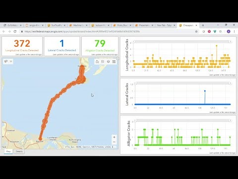
Object detection was demonstrated with the example of counting distressed pavement from video camera feeds. This demonstration featured Jupyter notebooks, and an operational dashboard. A key take-away from this example was that it is better to use multiple local models rather than a single global model.
-
Clustering groups observations based on the similarities in values and locations. This technique is used to uncover natural patterns. This was demonstrated with an exploration of the patterns in fatal vehicle accidents in the United States. This analysis was achieved using the density-based clustering tool built into ArcGIS which helps to separate clusters from noise. This tool supports several algorithms including DBSCAN, and HDBSCAN. A second example of clustering involved creating ferry routes for GPS data.
-
Prediction is the use of the known to estimate the unknown. This was demonstrated using the example of house price prediction in Summit County, Ohio. This demonstration employed a random forest approach to incorporate proximity to various spatial factors in the analysis.
Q & A
The talk ended with a question-and-answer session and some suggestions for how to get started. It was recommended that reading the Esri document “The Language of Spatial Analysis” would be an appropriate first step.
Reaction
Although transportation is not my main interest, I was excited to see the demonstrations of these practical examples of the application of machine intelligence to real world problems. This makes the technology more tangible and I now have a better understanding for the possibilities it offers. Clearly this is a powerful technology with many applications in diverse industry sectors. There is considerable overlap in both the Esri personnel and the content of this talk with some of the other talks I have previously summarized. I believe this repetition is good because I am beginning to feel more familiar with the topic. However, I realize that there is still a huge amount I need to learn about this subject.